Drainage
 |
| Rivers of India credits:wikipedia |
Q1(CBSE 2011): Describe the following drainage patterns of streams: (i) Radial
(ii) Dendritic
(iii) Trellis (3×1 = 3 marks)
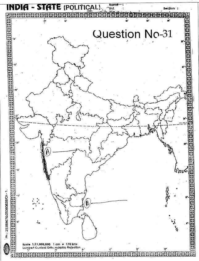
Q2(CBSE 2011): Two features (A) and (B) are marked on the given political outline map of India. Identify these features with the help of following information and write their correct names on the lines marked in the map.
(A) A mountain range
(B) A river (4 marks)

Q3(CBSE 2010): Which three rivers system forms the Himalayan river system?
Answer:
- The Indus River system
- The Ganga River System
- The Brahmaputra River System
Q4(CBSE 2010): Describe the three main features of river Brahmaputra.
Answers:
- Chemayungdung glacier (5150m) on the Kailas range about 100 km from the Manasarowar lake in Tibet is the source of the river Brahmaputra.
- Having a length of 2900 km, the Brahmaputra is one of the longest rivers of the world.
- Flows through Tibet, India and Bangladesh.
- Makes the world's largest delta jointly with Ganga.
- Tista, Manas, Luhit and Subansiri are the important tributaries.
- In Indian part, gets voluminous supply of water due to heavy rains and draining of tributaries. So it carries heavy load of silt during its course.
- Every year during the rainy season, the river overflows its banks and cause devastating floods in Assam and Bangladesh.
Q5(CBSE 2010/2011): Describe the three main features of Narmada Basin.
Q6(CBSE 2010): Give any three differences between peninsular and Himalayan rivers.
Q7(CBSE 2010): Explain the ‘National River Conservation Plan’ (NRCP) in brief.
Q8(CBSE 2010): Give any three differences between peninsular and Himalayan rivers.
Answer:
| Himalayan Rivers | Peninsular Rivers |
|---|---|
| 1. Glaciers are the source of most of the Himalayan rivers. Perennial in nature and exhibit smaller variation in volume throughout year. | 1. Supply of water largely depends on monsoon rain. These are seasonal and exhibit large variation in volume throughout year. |
| 2. Gorges carved by them indicate these rivers are young. | 2. Wide and Shallow valleys occupied by these rivers tell that these have reached their age. |
| 3. Have large basins and catchment areas. | 3. Small basins and catchment areas |
| 4. Do intense erosional activities | 4. Do little erosional activities. |
| 5. In lower courses develop meanders. | 5. Generally, these rivers have straight courses. |
| 6. Longer courses passing through mountains, plains and delta regions. | 6. Smaller courses flow through plateau and coastal plains. |
| 7. Frequent intense floods | 7. Less frequent as well as less intense. |
| 8. Great potential for hydro power. Brings benefits for irrigation and navigation. | 8. Limited use of irrigation and power generation. Low feasibility for power plants. |
Q9(CBSE 2010): Where does river Brahmaputra rise? Where does it enter into India? Name two of its tributaries.
Q10(CBSE 2010): What is the difference between tributary and the distributary? Write any three points.
Q11(CBSE 2011): How are the West flowing rivers different from the East flowing rivers of Peninsular Plateau? Give any three points of distinction.
Answer:
| East Flowing Peninsular Rivers | West Flowing Peninsular Rivers |
|---|---|
| 1. Major Rivers: Mahanadi, Krishna, Godavari and Kaveri | 1. Narmada, Tapi and Mahi |
| 2. Rivers drain into Bay of Bengal | 2. These rivers fall into the Arabian Sea. |
| 3. Flow through wide shallow valleys and form deltas at their mouth. | 3. Flows through narrow rift valleys and enter sea through estuaries. |
| 4. Have large basins | 4. Have smaller basins |
Q12(CBSE 2011): Two features (A) and (B) are marked on the given political outline map of India. Identify these features with the help of the following information and write their correct names on the lines drawn on the map :
(A) Northern part of the Western coastal strip.
(B) A river of South India.
Locate and label the following on the same political outline map of India :
(1) Anai Mudi
(2) Southern most point of the main land of India.
Q13(CBSE 2011): Define Drainage basin and describe two patterns of drainage in India. (1+2 = 3 marks)
Q14: (a) Explain the formation of fresh water lakes in the Himalayan region. Give two examples of fresh water lakes of this region.
(b) How is Sambhar lake useful ? (1+2 = 3 marks)
Q15: Which of the factors mainly controls the drainage system of the Indian subcontinent? Into which major groups are the Indian rivers divided? Write three points of difference between the two.
Q16(CBSE 2011): Where does the river Indus rise from ? What is its length ? Write any two tributaries of river Indus.
Q17(CBSE 2010): How does a river affect the economy of a country? (3 marks)
Answer: (Explain the following Hints)
- Basic natural resource - essential for various human activities.
- Civilizations started at river banks. Settlements turned into big cities.
- Livelihood of the majority of its population - irrigation for agriculture, fisheries
- Other Major uses like navigation, hydro-power generation
Q18(CBSE 2010): Name any two major river systems of the Himalayan region. Describe any one in detail. (4marks)
Q19(CBSE 2011): Explain any three causes of river water pollution ?
Q(CBSE 2011): What are the three main causes of river pollution ? Suggest some way to overcome each of them ?
Q20(CBSE 2011): Two features (A) and (B) are marked on the political outline map of India. Identify these features with the help of following information and write their correct names on the lines mark in the map :
(A) A Himalayan Range
(B) A River
And
Locate and label the following on the same political outline map of India. (1) Nanda Devi (2) Southern most point of mainland of India. (2+2=4 marks)
Q21(CBSE 2011): Write any three characteristic features of the Peninsular rivers?
Q22: Where does river Narmada originate? Name any two picturesque locations formed by it.
Answer: The Narmada rises in the Amarkantak hills in Madhya Pradesh. It flows towards the west
in a rift valley formed due to faulting.
The ‘Marble rocks’, near Jabalpur where the Narmada flows through a deep gorge, and the ‘Dhuadhar falls’ where the river plunges over steep rocks, are some of picturesque locations.
Q23: Name the long rivers which flow west and form esturies.
Answer: The Narmada and the Tapi are the only long rivers, which flow west and make esturies.
Q24: What is special about Sivasamudram?
Answer: The river Kaveri makes the second biggest waterfall in India. It is known as Sivasamudram. The fall supplies hydroelectric power to Mysore, Bangalore and the Kolar Gold Field.


Thank you helped me a lot while preparing :)
ReplyDeleteOnly Thank You is not enough!
Deletehuh...at least give the answers of all questions...we will search in books or what for those question. . .-_-
ReplyDelete@SAGARIKA SAIKIA , At least appreciate the author's effort . He is doing all of this free of cost taking the initiative . Do you own and manage such a useful blog - NO YOU DONT . So in a nutshell , SHUT UP or state yourself in a polite manner . You could have simply written - Pl provide the answers to the questions or something of that sort . And , ... -____-
DeleteHaha lol # burned.
Delete@SAGARIKA SAIKIA , At least appreciate the author's effort . He is doing all of this free of cost taking the initiative . Do you own and manage such a useful blog - NO YOU DONT . So in a nutshell , SHUT UP or state yourself in a polite manner . You could have simply written - Pl provide the answers to the questions or something of that sort . And , ... -____-
ReplyDeletecant take a print,shit page
ReplyDeleteHi,ppls sum1 ans my question .....my que is what are similarities between himalayan river and peninsular river?plssssssssss its urgenttttttttt
ReplyDeleteIt's already there in the question paper, which is Question no. 8
DeleteNic thank u plzz make it printable!
ReplyDeleteits printable
ReplyDeleteThank u
ReplyDeletetihs is helpful
ReplyDeleteThx a lot I really love this site
ReplyDeleteHmmm... i'd really appreciate if the author had given me all the answers.
ReplyDeletecan u please give answers also ???????????????? its really very urgent
ReplyDeletereally helpful
ReplyDeletethanks
ReplyDeletereally! it was very helpful.. but please provide answers to all the questions :)
ReplyDeletethanks a lot
ReplyDeletevery helpful and informative blog love it..
ReplyDeleteUr blog helped me a lot.....tq for sharing.. kindly mention all the answers....it will be more helpful😊
ReplyDelete